
Hey everyone!
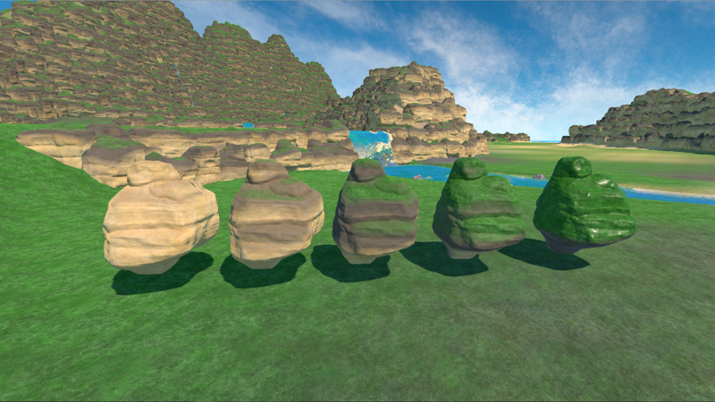
Last week was spent on more world building, but as part of that, I also ended up creating a new system for how the terrain rocks are coloured, which I want to talk about today.
Two weeks ago, I mentioned that our plans for 0.9 included creating a system of fertility for the islands, which will affect where fields can be placed (and where they can’t), how productive they will be, and maybe we will even introduce different fertility requirements for different crops, meaning that some areas will be great to farm coffee but can’t grow wheat, or vice versa. Two weeks ago I also mentioned that I am not always great at keeping to the order in which I’ve decided to work on things, and so I ended up doing a substantial part of the work required for this fertility system last week.
The reason for that is relatively straightforward: We wanted different biomes to reflect different levels of humidity/aridness to allow us to have a wet, jungle environment, or a drier pine environment. The rocks we have shown you in previous posts were all set up to look rather dry and desert-like. While that look is pretty nice by itself, it doesn't necessarily fit the lush jungle feeling that we wanted from a lot of the island, nor a lot of the tropical feeling we already have in a lot of places. As a result, we wanted the colour of the rocks to change depending on the area on the island and how wet we expect this area to be - which required giving our shaders some variables for moss growth, weathering of the rock, etc.
Originally, we thought that we would simply manually set the colour of the rocks to reflect the humidity we wanted, but we realised that the strong contrast between the dryness of the rocks did not look great. Likewise, we wanted to be able to introduce at least some variety within the same biome (e.g. wetter rocks closer to streams and rivers), and we needed a different approach to making that happen than simply setting colours manually.
This brought us to creating a humidity map. You can imagine this as a simple top down image of the island, telling the rocks where areas are wet and where areas are dry - with them adjusting their colours automatically. The result works quite well, and we will try to base further developments, such as moss on tree bark or weathering of buildings based on this map as well.
In world building news, I have finished the mountains for the first biome, and with the humidity map done, I can start populating it with some trees and plants as well. I will also continue placing rocks for the second biome that I am almost finished with, so hopefully I should be able to get both done by next week.
Until next week!